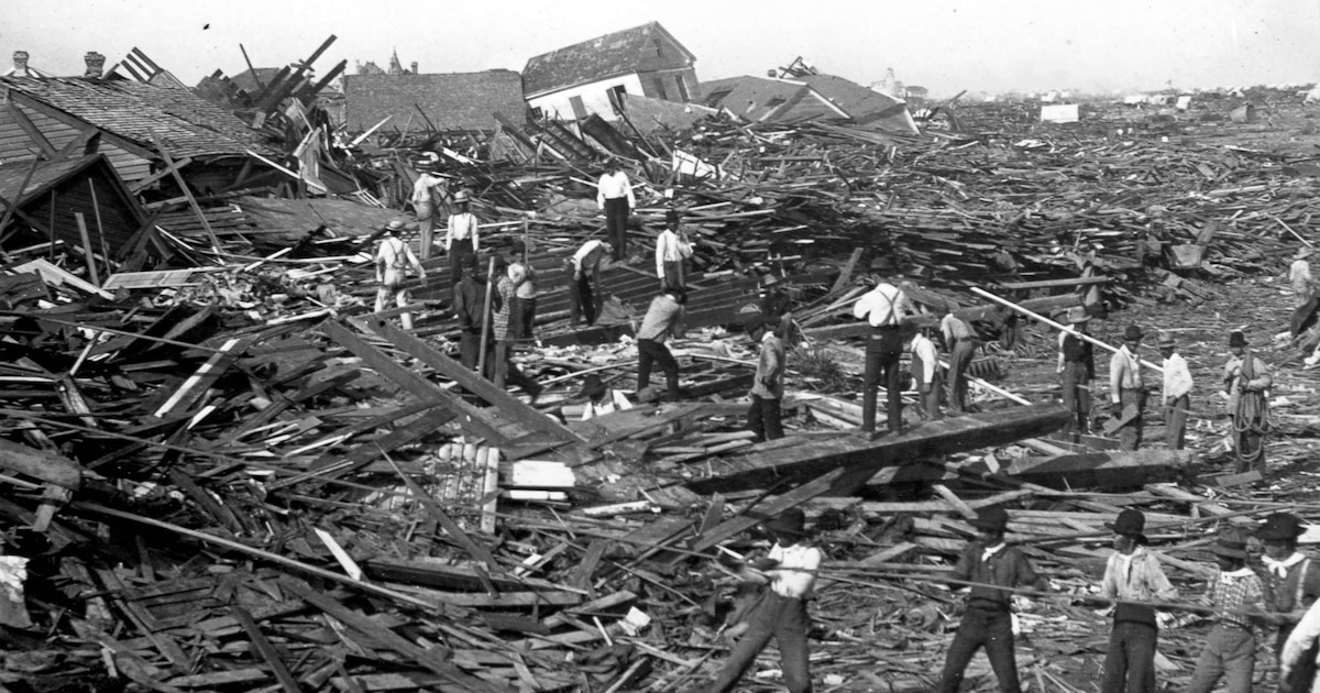
The Galveston hurricane of 1900 remains the most fatal natural disaster in U.S. history, claiming between 6,000 and 12,000 lives when it struck the Texas coast on September 8. The Category 4 storm devastated the island city, destroying approximately 4,000 buildings and wiping out nearly 20% of its population. Adjusted for inflation, the damage amounted to an estimated $104.3 billion, reshaping both the urban landscape and economic trajectory of the region.\n\nAt the turn of the 20th century, Galveston was a thriving commercial hub in the Gulf of Mexico, home to around 30,000 residents. Prior to the storm’s arrival, warnings were sent via telegraph after sailors reported severe weather in the Caribbean. “It began raining heavily around 4:00 a.m. on September 7, the first large waves arrived, and the barometer dropped sharply,” noted a report from the National Weather Service cited by The Washington Post.\n\nDriven by winds gusting up to 233 kilometers per hour, the storm surge exceeded the highest elevation of the inhabited area—just 2.7 meters above sea level. Once the hurricane made landfall, floodwaters reached depths of up to 4.6 meters, engulfing homes, businesses, and docks. Between 2,000 and 4,000 structures were reduced to rubble within hours. “We watched as the city disappeared underwater while the wind ripped doors and windows off,” recalled a survivor, as reported by The Associated Press.\n\nThe aftermath prompted a reevaluation of Galveston’s role as a major port. Doubts grew over the feasibility of rebuilding a commercial center so vulnerable to hurricanes. By 1914, a navigation channel was completed to Houston, then a much smaller neighboring city, which opened an alternative port. This shift redirected investment and jobs. By 1910, Galveston’s population had barely surpassed 37,000, while Houston approached 80,000, according to official census records.\n\nRecovery efforts prioritized disaster prevention. The Galveston Seawall, a 5.2-meter-high barrier designed to protect against storm surges, was constructed and now spans nearly 16 kilometers of coastline, featuring the longest continuous sidewalk in the United States. Additionally, large sections of the island were elevated using sand dredged from nearby channels, raising the ground level from under 2.7 meters to 3.4 meters. “This plan ensured that about 500 city blocks were safeguarded against future flooding,” stated the National Weather Service.\n\nThe catastrophe also accelerated advancements in hurricane forecasting. At the time, meteorological predictions relied on direct measurements of atmospheric pressure, wind speed, and direction. In response, authorities expanded a network of telegraph and radio alerts from ships at sea to provide earlier warnings. “The tragedy of 1900 underscored the urgent need to improve storm prediction,” emphasized a meteorological report reflecting on the event.\n\n— news from Infobae\n\n— News Original —\nAsí fue el paso del huracán de Galveston en 1900: el desastre meteorológico más mortal de la historia de EEUU\nThe hurricane of Galveston in 1900 remains the deadliest meteorological disaster in the history of the United States, after devastating the Texan city on September 8 and causing the death of between 6,000 and 12,000 people.\nThe storm, category 4, destroyed up to 4,000 buildings and eliminated about 20% of the local population, abruptly altering the economic and social destiny of the region. The impact on the island resulted in damages estimated, adjusted for inflation, at 104.3 billion dollars, in addition to modifying the urban development of the area.\nAt the beginning of the 20th century, Galveston was among the main commercial centers of the Gulf of Mexico, with a population close to 30,000 inhabitants. Before the arrival of the cyclone, bad weather alerts circulated by telegram after sailors reported adverse conditions in the Caribbean.\n”It began to rain heavily around 4:00 a.m. on September 7, the first large waves arrived and the barometer fell sharply,” describes one of the reports disseminated by the National Weather Service itself, cited by The Washington Post.\nThe rise in tide, driven by winds with gusts of up to 233 kilometers per hour, exceeded the maximum height of the inhabited terrain, which at that time was only 2.7 meters above sea level. Once the hurricane made landfall, the water reached depths of up to 4.6 meters, overflowing homes, businesses and docks.\nBetween 2,000 and 4,000 buildings were reduced to rubble in a few hours. “We saw how the city disappeared under water while the wind ripped off doors and windows,” recounted a survivor cited by The Associated Press.\nThe aftermath of the Galveston hurricane reconfigured the economy of the region. After the catastrophe, doubts arose about the viability of rebuilding a commercial hub exposed to such natural threats.\nA Reuters report recalls that by 1914 a navigation channel to Houston was completed, a neighboring city then much smaller, where an alternative port was opened. This work redirected the flow of investments and jobs. By 1910, Galveston’s population barely exceeded 37,000 inhabitants, while Houston was approaching 80,000, according to official census records.\nThe effort to rebuild the city focused on preventing similar catastrophes. Among the main works emerged the Galveston Sea Wall, a seawall 5.2 meters high designed to block future storm surges and safeguard 50 urban blocks. Currently, this structure spans almost 16 kilometers of coastline and exhibits the longest continuous sidewalk in the United States.\nThe recovery project also included the elevation of much of the island. Workers dredged sand from the channel and used it to raise the urban ground level from less than 2.7 meters to 3.4 meters. “The plan allowed about 500 urban blocks to be protected against future floods,” states the National Weather Service.\nThe devastation in Galveston spurred the development of tools to anticipate the arrival of hurricanes. At the beginning of the century, weather forecasts depended on direct observations of atmospheric pressure, wind speed and direction.\nFollowing the disaster, authorities strengthened a network to collect alerts via telegraph and radio from ships, in order to achieve more timely warnings for the population. “The tragedy of 1900 highlighted the urgent need to improve storm prediction,” emphasizes the same meteorological report.